


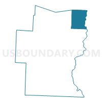
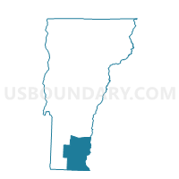
Rockingham Voting District, Windham County, Vermont
About
Outline

Summary
| Unique Area Identifier | 680922 |
| Name | Rockingham Voting District |
| County | Windham County |
| State | Vermont |
| Area (square miles) | 42.23 |
| Land Area (square miles) | 41.43 |
| Water Area (square miles) | 0.79 |
| % of Land Area | 98.13 |
| % of Water Area | 1.87 |
| Latitude of the Internal Point | 43.17120040 |
| Longtitude of the Internal Point | -72.50649770 |
Maps

Graphs
Select a template below for downloading or customizing gragh for Rockingham Voting District, Windham County, Vermont


Neighbors
Neighoring Voting District (by Name) Neighboring Voting District on the Map
- Athens Voting District, Windham County, VT
- Chester Voting District, Windsor County, VT
- Grafton Voting District, Windham County, VT
- Springfield District 2, Windsor County, VT
- TOWN OF CHARLESTOWN Voting District, Sullivan County, NH
- TOWN OF WALPOLE Voting District, Cheshire County, NH
- Westminster District 1, Windham County, VT
- Westminster District 2, Windham County, VT
Top 10 Neighboring County Subdivision (by Population) Neighboring County Subdivision on the Map
- Springfield town, Windsor County, VT (9,373)
- Rockingham town, Windham County, VT (5,282)
- Charlestown town, Sullivan County, NH (5,114)
- Walpole town, Cheshire County, NH (3,734)
- Westminster town, Windham County, VT (3,178)
- Chester town, Windsor County, VT (3,154)
- Grafton town, Windham County, VT (679)
- Athens town, Windham County, VT (442)
Top 10 Neighboring Place (by Population) Neighboring Place on the Map
- Bellows Falls village, VT (3,148)
- Saxtons River village, VT (565)
- North Westminster village, VT (247)
Top 10 Neighboring Elementary School District (by Population) Neighboring Elementary School District on the Map
- Rockingham School District, VT (5,282)
- Chester-Andover Union School District 29, VT (3,621)
- Westminster School District, VT (3,178)
- Athens/Grafton Joint Contract School District, VT (1,121)
Top 10 Neighboring Secondary School District (by Population) Neighboring Secondary School District on the Map
- Bellows Falls Union High School District 27, VT (9,581)
- Green Mountain Union High School District 35, VT (4,988)
Top 10 Neighboring Unified School District (by Population) Neighboring Unified School District on the Map
Top 10 Neighboring State Legislative District Lower Chamber (by Population) Neighboring State Legislative District Lower Chamber on the Map
- State House District 2, Cheshire County, NH (9,280)
- Windsor-1-2 State House District, VT (9,247)
- Windham-5 State House District, VT (7,744)
- Windham-4 State House District, VT (7,352)
- State House District 5, Sullivan County, NH (6,693)
- Windsor-1-1 State House District, VT (3,991)
Top 10 Neighboring State Legislative District Upper Chamber (by Population) Neighboring State Legislative District Upper Chamber on the Map
- Windsor State Senate District, VT (56,670)
- State Senate District 8, NH (54,222)
- Windham State Senate District, VT (42,637)
Top 10 Neighboring 111th Congressional District (by Population) Neighboring 111th Congressional District on the Map
Top 10 Neighboring Census Tract (by Population) Neighboring Census Tract on the Map
- Census Tract 9757, Sullivan County, NH (5,114)
- Census Tract 9666, Windsor County, VT (5,075)
- Census Tract 9665, Windsor County, VT (4,187)
- Census Tract 9702, Cheshire County, NH (3,734)
- Census Tract 9672, Windham County, VT (3,302)
- Census Tract 9670, Windham County, VT (3,251)
- Census Tract 9676, Windham County, VT (3,178)
- Census Tract 9671, Windham County, VT (2,031)
Top 10 Neighboring 5-Digit ZIP Code Tabulation Area (by Population) Neighboring 5-Digit ZIP Code Tabulation Area on the Map
- 05156, VT (9,226)
- 03603, NH (5,412)
- 05346, VT (5,184)
- 05101, VT (4,643)
- 05143, VT (4,343)
- 03608, NH (2,811)
- 05158, VT (1,049)
- 03609, NH (854)
- 05146, VT (750)
- 05154, VT (661)